Viewer Applications & Composition

| Item |
Viewer Type |
Format |
Device |
Note |
| 2D |
P&ID Viewer |
PDF |
Web |
|
| 3D |
Comos Walkinside |
JT, DGN, OBJ, DWF |
PC, Web, Mobile, VR |
|
| Autodesk Forge |
RVT, DGN, DWG, NWD, etc. |
Web |
|
| Unity |
FBX, OBJ, DXF, 3DS |
PC,Web,Mobile,VR,AR |
|
| Bentley i-Model |
DGN, RVT, DWG |
Web |
|
| Cesium |
GITF, GIB, GML |
Web |
|
P&ID Viewer
Overview
P&ID Viewer is an original software that converts CAD files and Image Legacy data to Readable PDF, extracts and groups property information, and generates intelligent I-P&IDs.
Data Format
| Manufacturer |
Program |
Data Extension |
| - |
P&ID Viewer |
.pdf |
Key Features
ㆍ Provides basic functions of PDF Viewer (zoom-in, zoom-out, page alignment, printing, etc.)
ㆍ Grouped object of I-P&ID, model and data linkage

Performance
ㆍ Chuncheon Energy : Establish integrated facility management and site-oriented technology information system
ㆍ Doosan Heavy Industries & Construction : Digital Plant Portal Feasibility
Comos Walkinside
Overview
Comos Walkinside is a 3D simulation software with the ability to convert large and complex 3D CAD models to “Walk in real space (Walkinside)” in a virtual space without visiting the actual site. Users move around in a 3D space designed with the eyes of a virtual character, check the distance between facilities, use facilities and accurately find locations on complex drawings to support successful project.
Data Format
| Manufacturer |
Program |
Category |
Data Extension |
| SIEMENS |
Comos Walkinside Builder |
CAD Files |
.JT*, .DGN*, .OBJ* , .DWF* |
| CAD Program |
PDMS, Microstation, PDS, SMART 3D |
| Data Files |
Point Cloud Files |
Key Features
ㆍ Realistic Virtual Reality: Using 3D characters identical to humans, navigation is performed as if walking in a real field.
ㆍ One Integrated System: COMOS Walkinside manages all data from design to operation, such as 2D and 3D, P&ID, and Single Diagram, in one integrated system based on one DB.
ㆍ Efficient Cooperation Training (HSE & SOP)
ㆍ Helps reduce accidents through simulation training.
Autodesk Forge
Based on the 2D and 3D viewer platform Forge, we build customized solutions including various applications such as process scheduling management, 4D simulation, and real-time data management.
Data Format
| Manufacturer |
Program |
Category |
Data Extension |
| Autodesk |
Forge |
3D Image Files |
3DM, 3DS, DAE, DWF, F3D, FBX, GLTF, IFC, IGE, IGES, MAX, OBJ, PAR, SKP, STEP, STP, VUE, XPR |
| CAD Files |
BRD, BPM, CAM360, CATPART, CATPRODUCT, CGR, DGK, DGN, DLV3, DWFX, DWG, DXF, EMODEL, G, GBXML, IAM, IDW, IGS, IPT, JT, MODEL, NEU, NWC, NWD, PRT, PSM, PSMODEL, SAB, SAT, SLDASM, SLDPRT, STL, X_B, X_T |
| Compressed Files |
STPZ, ZIP |
| Data Files |
IWM, PPT, RVT, SMB, XAS |
| Developer Files |
A, ASM, DDX, EXP |
| GIS Files |
DMT, GLB, OSB |
| Project Files |
PMLPRJ, PMLPRJZ |
| Raster Image Files |
DDZ, JPG, PNG |
| Other |
DOC, AXM, DWT, PDF, VPB, WIRE |
Key Features
ㆍ Model conversion and display in a web browser / Model-related functions such as model section view, measurement, and disassembly
ㆍ Integration with BIM 360 document management program
ㆍ Markup, print and link sharing
ㆍ Data visualization and analysis, photo data-based 3D modeling, AR and VR integration
ㆍ Product catalog and creation / design process automation
ㆍ SaaS product integration

Model-related functions like model section view, measurement, and disassembly

Integration with BIM 360 document management program

Markup, print, and link sharing

Data visualization & analysis
Performance

Quality management system using Dynamo

Forge-based 4D simulation system

Forge-based gas turbine monitoring system
Unity
Overview
ㆍ Visualization-based 3D Viewer that can be linked with facility and material database through 3D model formats such as FBX or OBJ-based models.
ㆍ Easy customization thanks to the game engine developed with our own technology
ㆍ Develop unique products that reflect the rapidly changing needs of the industry through the 3D visualization function using Unity.
Data Format
| Manufacturer |
Program |
Category |
Data Extension |
| Unity |
Unity Editor |
3D Model |
FBX, DAE, 3DS, DXF, OBJ |
| Reflect |
3rd Party Support |
Revit, Navisworks, Sketchup, Rhino |
| Pixyz |
Application |
Plugin for Unity, Studio, Batch |
Key Features
| Year |
Client |
Objective |
| 2017 |
Chuncheon Energy |
Establish integrated facility management and site-oriented technology information system |
| 2019 |
KHNP |
Shin-Kori Units 5&6 Configuration Management System |
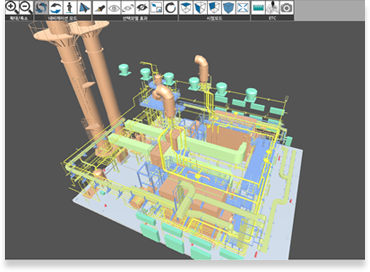
Viewer Main
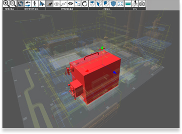
Model Highlight
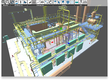
Model Translation
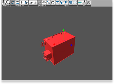
Model Only Show
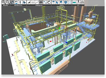
Model Only Hide
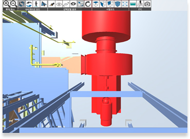
Model JumpTo
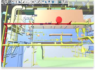
Model Distance
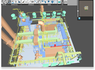
Model KeyMap
Bentley i-Model
Overview
ㆍ i-Model is a format for exchanging project information that occurs in the life cycle of the design, construction and operation of infrastructure assets.
ㆍ In an open format, it provides a standard interface for construction and engineering that allows sharing of all components including property information, geometry, graphics and relationships.
Data Format
| Manufacturer |
Program |
Data Extension |
| Autodesk |
AutoCAD |
.dwg |
| Revit |
.rvt |
| Bentley |
Microstation |
.dgn |
| OpenPlant |
| Trimble |
Sketchup |
|
| Rhino |
Rhino |
|
Key Features
ㆍ Effective and efficient sharing and distribution (reduce errors, shorten schedule, reduce cost)
ㆍ Various data sources and formats can be integrated.
ㆍ Information can be shared and distributed regardless of data source.
Cesium
Overview
ㆍ Cesium is an open platform for developing 3D geospatial data software applications.
ㆍ It is an end-to-end platform that allows developers to easily visualize, analyze and share 3D content.
ㆍ Recently, geospatial data-based visualization technology is required for services such as smart cities, digital twins, and smart construction, and WebGL-based geospatial data services can be developed using Cesium, an open source-based 3D visualization platform.
Data Format
| Manufacturer |
Program |
Data Extension |
| - |
- |
.glTF, .glb |
| - |
GIS file formats |
.kml, .GeoJSON |
| Open Geospatial Consortium |
XML based markup language |
.gml |
Key Features
ㆍ Importing data
ㆍ Streaming and visualization
ㆍ 3D style / filter / query / measurement analysis

Terrain drawing & satellite photo-taking via Cesium icon

Display regions via .KML

Arrangement of 3D model terrain & Visualization of buildings via Qgia

Check model information to select a 3D model